“Red sky at morning, sailors take warning.
Red sky at night, sailor's delight.”
It's easy to dismiss as folklore, but weather prediction has always been a matter of life and death to sailors. In the days before storm advisories and instruments like barometers, the best they could do was to watch the sky—and they found they could learn a lot that way about the next day's weather. So while folk predictions for the upcoming growing season are no better than guesses, nautical weather lore usually has some basis in truth. The venerable “red sky” rhyme is one of these. It works because light scatters differently through haze and cloud droplets than it does through clean, dry air (see Mie scattering for the optical physics). It also assumes that storm systems travel from west to east, hence sunset and sunrise in the rhyme. How good is that assumption? It depends on your latitude.
The trade winds these early sailors relied on make up what is known as the general circulation of the atmosphere: the global-scale, semi-permanent pattern in which all other weather moves and develops. It begins at the Equator—or more accurately at the thermal Equator, the intertropical convergence zone (ITCZ). I called the circulation “semi-permanent” before. This is because the ITCZ moves with the seasons, closer to us in the summer and farther away in the winter. You've heard that warm air rises and cold air sinks. The ITCZ is the line on the earth's surface where, thanks to the heat of direct tropical sunlight, the rising motion of warm air is stronger than it is anywhere else on the planet. Here it is now over Africa, courtesy of NOAA:

When air rises at the ITCZ, it creates an area of low pressure that cooler air rushes in to fill. And the rising air eventually spreads out in the upper atmosphere and flows away from the ITCZ, eventually sinking back to the surface somewhere in the subtropics. This completes a circle known as the Hadley cell. The Northern Hemisphere and the Southern Hemisphere each have one. Since rising air is associated with precipitation and sinking air with dry weather, it's easy to pick out the vertical parts of the Hadley cell on a map of biomes: notice how many of the world's deserts come in bands near 30° N and S, and how tropical rainforest is always situated close to the Equator. Less easy to spot are the Ferrel cells, which cover the planet roughly between 30° and 60° N and S, and the self-explanatory polar cells. Still, the rising motion near 60° N on the boundary between the Ferrel and polar cells is responsible for the storminess of the North Atlantic and the seas around the Aleutian Islands, and its counterpart in the Southern Hemisphere is what made the Southern Ocean so dangerous to sailing ships.

So far I've talked about the vertical and north-south components of the general circulation, but these do not explain the east-west trade winds unless you take the planet's rotation into account. Think of a parcel of air moving from the North Pole toward the Equator as part of the polar cell. It is close to the surface, but not of a piece with the solid Earth, and it does not have to rotate with the planet.
Near the axis of the Earth's rotation, a point on the surface does not have to move very fast to cover 360° in a day; a point on the Equator moves the entire circumference of Earth in the same time. So it follows that as the air parcel moves straight south, it would also have to go faster and faster eastward to keep up with the rotation of the planet. Since it does not, its position relative to the surface moves westward, and the point on the surface feels the passage of the air parcel as an easterly (i.e. out of the east) wind. More generally, this is the Coriolis effect: movement on the rotating Earth is deflected to the right in the Northern Hemisphere, and to the left in the Southern Hemisphere. (It has nothing to do with the flow down a household drain, however; the effect is so weak that it is only visible at large scales).
So applying the Coriolis effect to the north-south motion of the Hadley cell near the surface, we find that the wind should be deflected westward, resulting in trade winds that blow more-or-less diagonally westward and toward the Equator. In the Ferrel cell, the winds blow away from the Equator and eastward. In the polar cell, it's toward the Equator and westward again.
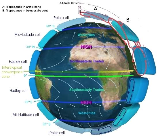
Though no one put the pieces together until the eighteenth century, this is in fact the pattern of trade winds that sailors have observed for hundreds of years. The “red sky” rhyme is valid only in the Ferrel cells, sure, because that's where there are westerly prevailing winds. But the Ferrel cells are also where the vast majority of humans have lived throughout our history, and where most of our shipping has taken place.
Thanks again, Virginia!
No comments:
Post a Comment